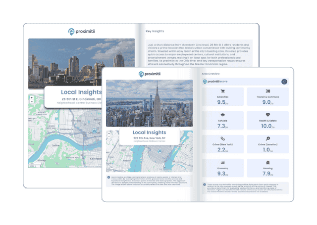
Why stop at city-to-city? With Local Insights, you can compare neighborhoods, zip codes, or even exact addresses. Access 300+ hyperlocal data points—from schools and crime to housing and amenities—to see which area is the better fit.
| Month | Temp. (min) | Temp. (max) | Temp. (avg) | Precipitation |
| January | 26°F | 39°F | 32°F | 5.5" |
| February | 23°F | 37°F | 30°F | 2.2" |
| March | 29°F | 45°F | 36°F | 6.7" |
| April | 37°F | 51°F | 44°F | 7.9" |
| May | 47°F | 60°F | 53°F | 6.7" |
| June | 57°F | 71°F | 63°F | 1.4" |
| July | 63°F | 77°F | 70°F | 5.0" |
| August | 64°F | 79°F | 71°F | 1.8" |
| September | 59°F | 74°F | 66°F | 4.9" |
| October | 51°F | 64°F | 57°F | 5.6" |
| November | 39°F | 54°F | 47°F | 4.6" |
| December | 30°F | 43°F | 36°F | 5.5" |

| Index | Chatham | Massachusetts | National |
| Air quality index | 36 | 40 | 42 |
| Pollution index | 7,903,830 | 8,399,610 | 2,726,193 |
| Measurement | Total |
| Days measured | 359 |
| Days with good air quality | 348 |
| Days with moderate air quality | 11 |
| Days w/ poor A.Q. for sensitive groups | 0 |
| Days with unhealthy air quality | 0 |
| Pollutant | Total |
| Arsenic | 0.060% |
| Benzene | 0.070% |
| Carbon Tetrachloride | 0.010% |
| Lead | 0.080% |
| Mercury | 0.030% |
| City | Population | Air Quality Index | National Avg. |
| West Chatham, MA | 1,224 | 36 | 28.0% |
| East Dennis, MA | 3,068 | 36 | 28.0% |
| Northwest Harwich, MA | 4,123 | 36 | 28.0% |
| South Yarmouth, MA | 10,598 | 36 | 28.0% |
| Brewster, MA | 1,347 | 36 | 28.0% |
| Chatham, MA | 1,550 | 36 | 28.0% |
| City | Population | Air Quality Index | National Avg. |
| Union Point, GA | 1,550 | 44 | 12.0% |
| Manning, IA | 1,550 | 40 | 20.0% |
| Falmouth Foreside, ME | 1,550 | 40 | 20.0% |
| Homer, MI | 1,550 | 38 | 24.0% |
| Sackets Harbor, NY | 1,550 | 35 | 30.0% |
| Chatham, MA | 1,550 | 36 | 28.0% |
 Here are the best places to live in Massachusetts
 See the best places to live in Chatham
 Most Dangerous States In The US
 These are the 10 cheapest cities in Massachusetts