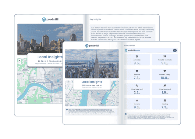
Why stop at city-to-city? With Local Insights, you can compare neighborhoods, zip codes, or even exact addresses. Access 300+ hyperlocal data points—from schools and crime to housing and amenities—to see which area is the better fit.
| Month | Temp. (min) | Temp. (max) | Temp. (avg) | Precipitation |
| January | 32°F | 47°F | 38°F | 6.1" |
| February | 34°F | 52°F | 42°F | 4.6" |
| March | 37°F | 57°F | 46°F | 5.7" |
| April | 39°F | 62°F | 50°F | 3.1" |
| May | 45°F | 70°F | 57°F | 2.5" |
| June | 50°F | 75°F | 62°F | 1.4" |
| July | 54°F | 83°F | 68°F | 0.3" |
| August | 54°F | 84°F | 68°F | 0.5" |
| September | 49°F | 78°F | 62°F | 1.6" |
| October | 43°F | 65°F | 53°F | 4.1" |
| November | 37°F | 53°F | 45°F | 7.1" |
| December | 32°F | 45°F | 38°F | 6.9" |

| Index | Deer Island | Oregon | National |
| Air quality index | 18 | 32 | 42 |
| Pollution index | 3,247,580 | 7,156,356 | 2,726,193 |
| Measurement | Total |
| Days measured | 360 |
| Days with good air quality | 338 |
| Days with moderate air quality | 22 |
| Days w/ poor A.Q. for sensitive groups | 0 |
| Days with unhealthy air quality | 0 |
| Pollutant | Total |
| Arsenic | 0.002% |
| Benzene | 0.020% |
| Carbon Tetrachloride | 0.500% |
| Lead | 0.040% |
| Mercury | 0.001% |
| City | Population | Air Quality Index | National Avg. |
| Woodland, WA | 6,223 | 18 | 64.0% |
| St. Helens, OR | 13,779 | 18 | 64.0% |
| Kelso, WA | 12,237 | 18 | 64.0% |
| Columbia City, OR | 1,770 | 18 | 64.0% |
| Longview, WA | 37,914 | 18 | 64.0% |
| Deer Island, OR | 105 | 18 | 64.0% |
| City | Population | Air Quality Index | National Avg. |
| Buckeye, IA | 105 | 37 | 26.0% |
| Tingley, IA | 105 | 39 | 22.0% |
| Unionville, IA | 105 | 39 | 22.0% |
| Lima, IL | 105 | 41 | 18.0% |
| Raglesville, IN | 105 | 1 | 98.0% |
| Deer Island, OR | 105 | 18 | 64.0% |
 Here are the best places to live in Oregon
 Check out the 10 safest cities in Oregon
 Safest States In The US
 These are the 10 cheapest cities in Oregon